Monday June 1st;
I decided to head back to those most beautiful of mountains The Pyrenees again this year to continue on my traverse from East to West. Last year I had reached just west of Auzat so this time I flew into Toulouse and got the train down to St Girons where I hitched a ride as far as the village of Seix from where I could easily re-join the GR10.
The fun started early as I had mis-remembered the train timetable for the morning of my trip (it being a bank holiday) and I arrived into Mallow train station at 08.30 to catch a train to Dublin for my 13.00 hours flight only to find the place deserted and discovered that the next train wasn't until 09.40. This wasn't due to get into Dublin until 11.55 which would give me precious time to travel the eight or so miles to the airport. I was terribly disappointed and sure I would miss my flight. I briefly thought of driving up but I realized that even if I drove like a madman it would probably take me longer to get sorted by the time I had parked my car etc, so I waited dejectedly for the train and took my chances. To my delight the train arrived into the station a little early and I alighted at 11.48. I ran down towards the taxi rank and one pulled out and drove towards me. I chucked in my bag and asked if he could make his best time to the airport for me. He was really nice and its fair to say he didn't obey the speed limits and even broke several amber lights and he unbelievably dropped me at the departures door at 12.08. I gave a hefty tip and ran in with renewed hope and I was just on time to drop my checked in bag. Travel through security was never so easy and I reached the departure gate with time to spare. OMG result...and breathe.
The remainder of the travel went smoothly with the only hiccup being after buying gas in Toulouse I missed my first train connection but didn't have too long to wait for the second. This meant it was almost 20.00 by the time I reached St Girons and after a 15 minute wait I got a lift from a man who actually drove out of his way to drop me at the gate of the campsite in Seix. I still couldn't quite believe I had made it.
Tuesday June 2nd;
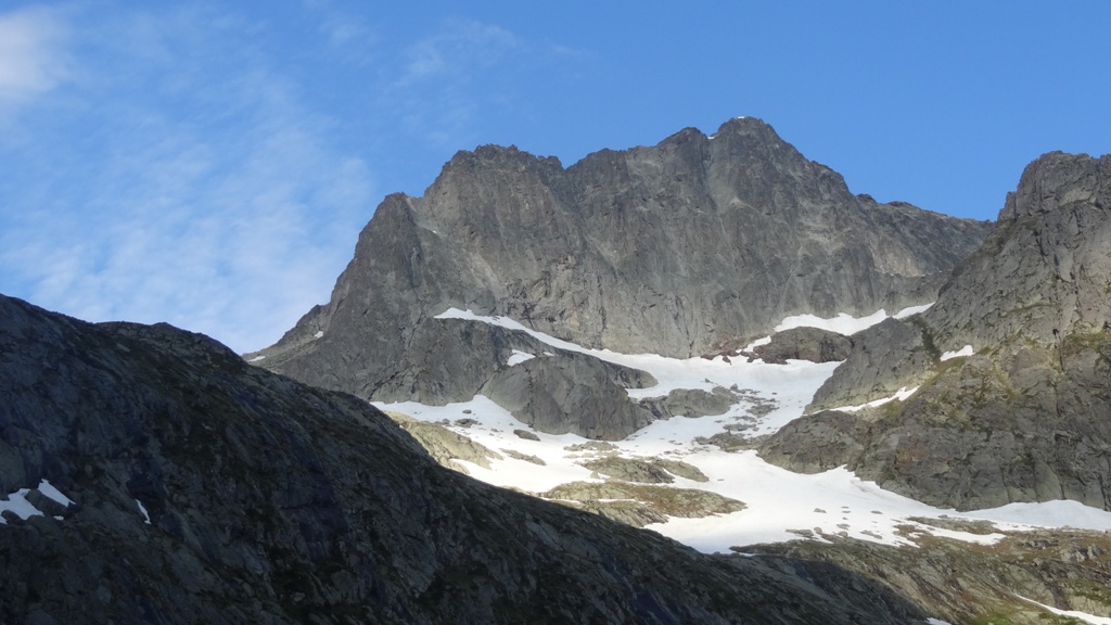
I got up to a warm clear morning that was alive with birdsong. I had my breakfast and was on the move at 07.20. As is usual the fully laden bag felt heavy but my spirits were sky high as I set of. A fifteen minute walk saw me through the village and on a lovely trail that ran alongside the river until after a couple of kilometers later I arrived at the little hamlet of Couflens de Betmajou where the GR10 followed a little country road for several kilometers gently uphill. After it passes the cluster of houses at Estours it crosses the river and becomes a forest type road until eventually at another river crossing the trail finally grows some teeth and heads directly uphill through the woods. After the gentle start the steep incline came as something of a shock to the system but I was pleased to find that I was able to maintain a steady pace and I gained height fairly quickly and before too long I was nudging the 1000 meter mark. It was still a relief when the gradient eased and the trail went through a wooded glen before eventually emerging into open pastureland at Cabane Forest de Lameza at 1339 mtrs. Ahead snow clad peaks formed a stunning backdrop and at the back of the open ground, before the mountain walls rose again, I could see the Refuge de Subera 1499 mtrs. Right here and now I was already into the heart of what these beautiful mountains are all about with their varied landscapes and floras and I was loving it. The real world already seemed far far away.
 |
| Walking towards Seix,,,the mountains beckon |
 |
| Finally leaving the forest and what a sight awaits |
 |
| Arriving at Refuge Subera |
By the time I reached the refuge I had been on the move for four hours and I was in need of a little break. I had planned to depart the GR10 here and follow the Chemin de Liberte route until I reached the Refuge des Estagnous 2245 mtrs under Mont Valier. This would involve climbing over the Col de Craberous at 2382 mtrs and continuing over the even higher Col de Pecouch at 2462 mtrs. It was a big ask with a heavy bag (approx 19 kilos including food for five days) so I didn't delay too long before setting off again. I had already climbed 1000 meters and if I was to get to where I hoped to go I had over a 1000 more to do. I was using the 1-50000 randonee maps and to be honest they are not great. I found the start of the trail OK but on the map it showed it turning back to the right after a few hundred meters as it gained height. I walked the trail for about half a mile and there was no sigh of it turning so I reasoned that I had continued on another trail (faintly marked on the map) and I retraced my steps. To cut a long story short I spent a full 1.5 hours trying to find a route up and climbed into several blind alleys before I frustratingly gave up on the idea as it was now too late in the day to attempt such a mammoth task. Now as I look at a more detailed map online I can see that the trail I originally followed was the right one and it indeed turned right not much beyond where I turned back (but much much further than marked on the map I had).
 |
| Beautiful landscape |
 |
| Looking back at Col de la Core with some weather threatening |
 |
| Passing some impressive rock faces near the Cabane |
 |
| The Cabane d'Eliet. 40 or so meters below the col ( and the water) |
 |
| Chillaxin in the evening sun |
 |
| Nice sunset |
My mood wasn't great as I rejoined the GR10 and headed for Col de la Core at 1339 mtrs some six kilometers away but it soon improved as I went on the long traverse of wonderful wild open mountain scenery. Once again I dropped down into woodland and eventually reached the road that passes over the col. Cloud had formed as the afternoon wore on and there were some distant rumbles of thunder to the east so I was keen to find somewhere to settle for the night. Looking at the map I saw that there was a Cabane up by Col d'Auedole 1725 mtrs so I set off for there. I was pretty whacked by now and the 300 meters of climbing to reach the col was pretty tough. The cabane itself was some 40 meters below the pass so I dropped down. I was delighted and disappointed at the same time when I discovered that the cabane was nice and clean inside with a nice sleeping area upstairs and no evidence of rodent infestation but that there was no water supply nearby. That meant I had to climb up to the col a couple of times over the evening to collect some water from a trickle that was coming from the patch of snow at the col. Still I was settled for the night and I set about relaxing for the rest of the evening. A little rain fell but no lightning materialized but the mosquitoes took a distinct liking to me and I was soon coming out in lumps in some uncomfortable places. Still I enjoyed my evening and slept very well.
Wednesday June 3rd;
I awoke to a beautiful clear morning and set about readying for the day ahead. I was somewhat surprised to see a mouse scurrying about as I ate breakfast but I wasn't bothered as he hadn't gone near my food in the night. I was out the door and on my way by 07.00. I have to say I was struggling and I could really feel the exertions of yesterday in my legs. Still the trail was fairly gentle and after I while I found a slow steady rhythm and made good progress and soon enough found myself in by Etang d'Eychelle at 1894 mtrs. I should say that the plan for today was to get to Refuge des Estagnous at 2245 mtrs which lay in the western shadow of Mont Valier 2838 mtrs and once there I would see if climbing the mountain was an option for later in the day. I had two cols to get over before I reached the refuge and there would be 900 mtrs of climbing just to reach there so I would see how I felt. After the lake I next reached the pastoral Cabane d'Eychelle at 1970 mtrs and after crossing the broad level pastures I reached the first proper snowfields that rose gently up to Col de la Crouzette at 2237 mtrs. New vistas greeted me here but I didn't delay and easily dropped the 140 meters on snowfields and reached the Cabane des Espugues at 2110 mtrs. If I had found the Chemin de Liberte yesterday the high col above me (Craberous) would have led me to this spot. However I kinda glad I had missed it as I was finding things today enough of a struggle.
 |
| A beautiful morning,,,and view to start the day |
 |
| Etang d;Eychelle |
 |
| Up by Cabane d;Eychelle |
The next section was a nice, mostly level traverse around the mountainside until I reached Etang Crousus 2139 mtrs which nestled in a lovely wild mountain coum. I crossed the outlet and climbed steeply up some bouldery ground which gained me good height before I had to continue the rest of the way to the next col Col de Pecouch 2462 mtrs entirely on snow. It was a long curved gently rising traverse to reach the col but the gentle gradient was offset by the soft snow which made for heavy going. It was now getting quite warm and it seemed to take an age before I finally arrived at the pass. The refuge could be seen just over 200 meters lower down and despite an initial steep drop the descent was swift and easy on good snow. It was a huge relief to drop my bag at the refuge at 11.15, over four hours since I set off. The refuge was still unmanned but the winter room was open and there was a fine dormitory and cooking/seating area available so I was set fair. I decided to have a bite to eat and decide what to do after that.
 |
| Easy snow slopes up to Col de la Couzette |
 |
| Lovely little stone cross at the col |
 |
| By the Cabane des Espugues looking towards Mont Valier |
 |
| Impressive high mountain scenery by Etang de Cruzous |
 |
| New vistas from Col de Pecouch |
 |
| The Refuge Des Estagneus |
After lunch I took stock of the weather which looked like it was set fair for the afternoon and I decided to go for the climb. I left all the stuff I wouldn't need for the climb ( which was most of what was in the bag) but I was still, lets just say, less than energetic as I set off across the snow field that led to the what looked like snow free slope that led all the way to the summit. I still brought the axe and crampons as I didn't want to be unprepared for any surprises I couldn't see. After the snow I climbed an easy rock spur to reach the slope that rose at a steady 40 degrees right up to the top. The normal track veers to the right to the col between Mont Valier and its smaller neighbour Petite Mont Valier which is just 100 meters lower, but this way was covered in snow so I stuck pretty close to the left hand side which was a little more exposed but offered nice little scrambly bits especially higher up. Steep and unrelenting it was but even though I had to stop for a rest fairly often, I made pretty quick progress and I found myself on the 2838 mtr summit at 14.30, almost exactly two hours after I set off. There was some cloud about so the views were not unrestricted but I was still treated to some wonderful vistas as I whiled away a very enjoyable 15 minutes. The return was more rapid even though care was needed as a fall would not have been a good idea as there really wasn't much to stop it turning catastrophic and I found myself back at the refuge by 16.00.
 |
| High on Mont Valier looking at "Petite" |
 |
| The refuge is a long way below right of the small little lake |
 |
| Mont Valier |
I enjoyed a long quiet evening and tried to recover as much as possible before the exertions of the following day. I had hoped to go from here via the GRT route all the way to Pic de Mauberme over the following couple of days and from there down to Vielha and then hopefully climb Aneto. However given how much I was struggling and looking at the amount of snow on my intended route I decided that it would be too difficult to make the progress I needed to make to keep on schedule so I opted for a change of plan and decided to follow the GR10 as far as Luchon and take it from there.
Thursday June 4th;
Happy birthday to me, happy....
On my 53rd birthday I got up nice and early and was out and at em by 7am. I emerged into another beautiful morning and it promised to make another hot day. The first obstacle of the day was the long way I had to descend, all the way to Pla Lalau at just 926 mtrs. The morning was beautiful and as I had plenty of food and my tent I wasn't in any particular rush to get anywhere. About half way down there is a lovely, quite large waterfall. I was admiring it as I went down but it was a bit of a surprise to find the bridge at its base was gone so I would have to wade across. I was glad to have my old (faux) crocks with me and off came the boots and I went across the freezing torrent. It's fair to say that my feet felt quite refreshed afterwards.
 |
| A stunning morning |
 |
| A curiousity on the way down |
 |
| Looking up at the waterfall. It was about 100 meters high |
 |
| A better view after I had crossed |
Eventually I reached the pretty picnic area at the bottom which meant I was faced with over 900 mtrs up to Clot du Lac. It was pretty hot by now and I was wondering how the legs would be on the climb. I wouldn't say I found it easy but I was again able to find a slow rhythm and I made reasonable progress. Eventually the woods were left behind and I once again entered high alpine pastures. I stopped for a drink at cabane Trapech and after a little rest set off again. After about 10 minutes I noticed that something was different and I realized I had left my walking poles behind. Damm and bollix to it. I only hoped that I hasn't left them further back at earlier rest stops. It was with some relief that I saw them leaning against the cabin wall. Still it was a pain to have to turn and repeat the climb again.
 |
| Down near the bottom..still beautiful |
 |
| Lush |
 |
| Vultures at carrion |
 |
| Big birds...these are not small trees |
 |
| I had to go back down for my sticks |
 |
| Sheep keeping cool by the col |
Soon enough I reached the col and set my mind to thinking about where I would settle for the day. I had been on the move for over 5 hours already and I didn't necessarily want to have a huge day. There was another 900 mtrs drop to the valley floor ahead so I decided to go that far and then take stock. On the way down I could see a beautifully situated cabin in a meadow at the bottom and that offered me a likely resting place. The weather was great and I don't really know why but when I reached the meadow after 7 hours of effort I opted to climb up to Col de l'Arech some 800 mtrs above and try to reach the gite at Eylie. It must be the masochist in me that drove me on but it's fair to say that I was very tired when I eventually dropped my bag for the day in the gite at six pm, some 11 hours since I set off with 3100 mtrs of descent, over 1800 mtrs of ascent and God knows how many kilometres. So much for the shorter day. On the plus side, the gite was lovely, with great showers and spotlessly clean. Rain and a little thunderstorm arrived just when I did, so I lucked out there as well. There was also a certain satisfaction in getting so much done. I slept very well again.
 |
| Mont Valier from Col de l'Arech |
 |
| Beautiful Beech woodland |
 |
| Col de l'Arech |
 |
| Eylie a long way below |
 |
| Rustic old gite...lovely inside |
Friday June 5th;
The GR10 passes right outside the door of the gite but it also starts to climb immediately. What would I do today?, how far would I go?. These were questions that could wait a while as there was the small matter of 1200 mtrs to climb before I reached the col before Etang d'Eraing at over 2200 mtrs. Initially I was struggling but again I found a rhythm and made steady progress. There is a lot of detritus and paraphernalia left from a mining past in this valley and its fair to say that it does impinge on the beauty of the area. The once again stunning weather helped and I found I was really enjoying myself. I reached the col and dropped down to the pretty lake where I briefly considered stopping at the nearby refuge. My ambitions had increased after the achievements of yesterday and I decided to head for a campsite in the village of Fos. From the lake there was a further 250 mtrs up to Col d'Aueran.
 |
| One of the many cable towers in the area |
 |
| Stunning scenery once again |
 |
| Pic de Mauberme..perhaps another time |
 |
| Etang d'Eraing |
 |
| An airy little summit |
 |
| Col d'Aueran |
I must have been getting a little stronger because by the time I reached the col I wasn't feeling too bad despite climbing about 1500 mtrs already. Even though I still had a long way to go I was looking forward to it as it was gently downhill. As I progressed towards the surprisingly boggy ground towards Uls, I was treated to the spectacular sight of a pair of large fighter jets shooting past me an over a nearby col and shortly afterwards returning only this time flying upside down. Thrilling. Again I re-entered the forest and wend a wound my way down. The trail eventually reached some houses and was on tarmac for the next 5 kilometres until I reached the pretty village of Melles. I felt my day nearing the end but I found that Fos was 200 mtrs lower and the campsite was still over 3 kilometres away. The heat of the day was reflected by the road and my feet could certainly feel it. I discovered that the campsite was closed so I stayed instead in the gite. It was okay but certainly not as clean as the one in Eylie.
 |
| By Uls...still a long way to go |
 |
| Lower down coming to the first barns |
 |
| Finally nearing Fos |
Saturday June 6th;
The obvious destination for today was Luchon. When I asked the gite guardian about the route he said it was a big day that took anything between 8 and 12 hours. It seemed that my short day would have to wait. I set out in another glorious weather morning and after a short section on the road I was once again swallowed up by the forest. Upward and ever onward and I eventually arrived at a lovely little cabane at 1300 mtrs. It is always a bit special to leave the woods behind and enter the sunkist open mountainside. Shortly afterwards I reached the twin cabanes at Courraux from where the Col d'Esclot d'Aou at 2093 mtrs could be seen. Overhead vultures circled (as they did in most high passes) and it all added to the beauty of the place.
 |
| A canal alongside the river Garonne...another lovely weather morn |
 |
| Are there woodpeckers about?? |
 |
| First cabane of the day |
 |
| Why build a wall when one is ready made |
 |
| Blue sky and mountains...bliss |
 |
| The way way back. |
 |
| New vistas appear |
 |
| Easy walking with great views |
Once I reached the col I had a bite to eat and I set off once again on the trail. Or at least I tried to but once again the trail on the ground differed from the map. It was supposed to drop down a hundred meters or so and then contour around the valley a cabane at Peyrehitte at 1947 mtrs but alas this wasn't the case and instead it stayed on the ridge and traversed over Pic de Bacanere which added more than a 100 mtrs to the climb. It did however have its compensations as after the broad top the walk to the cabane was beautiful. New vistas of new mountains swept away into the distance and promised fabulous future days. Upon reaching the cabane I got my first views down to Luchon so far below. Water was becoming a little bit of a problem as I hadn't passed a source for some time and it was again quite hot. Still there was nothing for it but to press on. Beautiful alpine pastures dominated the descent most of the way to the village of Artigue which was still over 500 mtrs above Luchon. I pressed on and after what seemed like a long time I reached the valley floor and set out to find a campsite. I reached a junction and saw a couple of signs pointing in opposite directions. I picking one and set off. After nearly a mile there was still no sign so I asked a guy loading a lawnmower into his van if it was nearby and he turned out to be an English man who said that the one in the other direction was better and right alongside a supermarket. He then drove me right to the entrance and saved me from further walking. What a gent. Today covered 28kilometres and had 1800 mtrs of ascent and took me 9 hours. I thought that tomorrow I would have a rest day. A few beers and a good feed was followed by a good sleep.
 |
| After Pic de Bacanere, lovely walking |
 |
| New ranges coming into view, mmmmm lovely |
 |
| First views of Luchon, its quite a large place |
 |
| Artech,,, there is a gite here so a shorter day is possible |
 |
| Luchon is still nearly 600 meters lower down. |
Sunday June 7th;
Once again I awoke to a beautiful morning. I luxuriated in a lie in and didn't get up until after 08.00. Strangely I felt strong and suddenly it seemed like a waste to take the day off. I packed everything up and after buying my return train ticket en route I set off to get to Refuge d'Espingo at 1967 mtrs. It was 9.20 when I left the campsite and 10.20 before I eventually found the right path out of town that set off up through the woods towards the ski resort of Superbagnere at 1800 mtrs some 1100 meters above. After that there was the Col de Cecire which at 2272 mtrs would be the high point of the day. Today was the hottest yet and I was aware that lightning storms were forecast for later in the day. I was moving pretty well and it wasn't yet 13.00 when I reached the impressive ski station with its apartments and hotels , restaurants etc. Unfortunately everything was closed which meant that even though I was parched by the time I got there I couldn't get a drink and as the way to the Col was on a crest it would be quite a while until the next source.
 |
| Nice gardens near the spa in town |
 |
| Leaving Luchon behind |
 |
| Some of the rather impressive ski resort |
 |
| Amazing views |
On the plus side the views were stupendous. Across the Vallee du Lis was arranged an alpine display as fine as you could wish to see. It constantly drew the eye and not just because I was scanning the sky to check on the cloud build-up. Delightful as it was, it was also evident that the thunderheads were forming so I pressed on for the col as best as I was able. I reasoned that once past there it would be downhill and so less dangerous in a storm. The col eventually arrived and I ate plenty of snow to slake my thirst. I also discovered that far from being exclusively downhill I had two more passes to go over in the next couple of kilometers and these added a further 250 meters to the climb. The main thing though was that the storm held off until I was only a few minutes from the refuge...result. So my rest day had in fact been anything but and involved approx 15 kilometers and 1900 meters of ascent and took me 8 hours. Still I was very happy to relax for the evening in the guarded refuge and take in the high mountain views all around.
 |
| Beautiful but the cloud is building |
 |
| Looking back from the final col |
 |
| Refuge |
 |
| Nice views to while away the evening with. |
Monday June 8th;
The plan for today was to climb Pic de Perdiguere which at 3222 mtrs was the highest in the area. I asked the guardian the previous evening about the route and he was very helpful and even lent me a better 1-25000 map which made navigation easier. I got up early and was out and en-route by 06.00. Guess what...it was another beautiful morning. Initially there is a drop in the trail to reach the lovely little Lac Saussat. Afterwards a well made trail gradually gained height until I reached the first snow slope at about 2200 mtrs where I eventually got to don my crampons. It felt good to finally put them to some use and I gained height quickly. There was some rocky ground barring the way and I took them off again once I reached it and made my way up to the Refuge du Portillon at 2570 mtrs which sits above the Lac du Portillon which is fronted by a small dam. Here all was rock and snow and felt very alpine indeed.
 |
| In by the lake, the way ahead is up to the left. |
 |
| Looking back |
 |
| Izards |


There is a trail that rises from the end of the dam and traverses some steep cliffs but in the conditions that prevailed I chose to descend from the dam and cross around just above the lake on snow from which a steep snow slope rose in the direction I wanted. The snow was lovely and firm and at about 40 degrees allowed me to gain height rapidly. Once above here the ground laid back considerably and easy slopes led to the Col Sup de Literole at 3049 mtrs. There followed a delightful scramble up an at times airy rock ridge to the summit. There was nothing too difficult and if one so chose you could turn any steep bits but I found it was much more fun to stick faithfully to the crest. All too soon the summit arrived and here I luxuriated in my environment for 15 minutes. I was on the summit at 11.30 and left at 11.45. Lots of time to get back to the refuge before the expected storm arrived. The return went well and the steep snow slope was all right even though the heat of the day had made the surface few inches soft. I reached the dam and as I was removing my crampons I was surprised to be spattered by a few big drops of rain. What the??. Sure enough when I looked up there was some ominous cloud coming overhead by Pic Lezat so I donned my rain jacket and wasted no time in heading down. Thankfully the rain was brief and soon I was baking in sunshine again. I had to stop to remove my jacket and set off again. Once I crested point 2508 mtrs I could see north and it didn't make a reassuring sight. A rapidly blackening sky with evident heavy rain underneath was headed directly my way. Bolts of lightning were also to be seen so I re-donned my jacket and set off down. Soon I was engulfed by the storm and I was quickly drenched and moving through a stream that was once a path. Thunder resounded from the slopes above but I suppose I really couldn't complain. I had been blessed with the weather so far in the trip and once I wasn't struck by lightning a bit of rain wouldn't do me any harm. I arrived back at the refuge intact at14.00 and just as the storm eased. I quickly changed into dry clothes and enjoyed a little celebratory beer. A long convivial evening ensued.
 |
| Approaching Refuge de Portillon |
 |
| Around the lake and up to the left |
 |
| A curious cascade across the way |
 |
| Pic Lezat |
 |
| Easy slopes up to the col |
 |
| The start of the crest to the summit |
 |
| Nice elegant line to the top |
 |
| Some summit views |
 |
| The refuge some 700 meters lower |
 |
| Looking towards Posets |
 |
| Aneto..the highest in the Pyrenees |
 |
| It was a wee bit chilly |
 |
| Back down the crest |
 |
| Very Alpine indeed |
Tuesday June 9th;
Again I got up early and after the early arrival of the storm the previous day I wanted to get back to Luchon in good time. Today I basically was retracing my steps from Sunday but obviously today would mean mostly descent. That's not to say there wouldn't be any climbing. I think there was about 600 mtrs in total. I arrived back at the campsite at 12.30 in brilliant sunshine and just chilled out for the rest of the day. I reflected on the previous days efforts and I felt a quiet satisfaction at how much I had done. Over the eight days I had covered God knows how many kilometers but I had been on the go for a total of 70 hours and climbed around 12000 meters. I had included two peaks and was now more than half way across the range. It had been a very successful trip and even though I changed my plans at the beginning I felt I had achieved a lot. I tooled around the campsite for the remainder of the day and after "re hydrating" over the evening I retired to my tent when rain arrived late in the evening.


The return home on Wednesday June 10 went uneventfully and I took the opportunity to have a wander around the pretty tourist town of Carcassonne before my flight home. I look forward to returning and continuing my exploration of this most beautiful of mountain ranges. Now where to next?.